
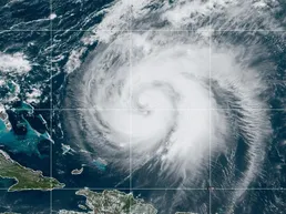
Since August 7th, meteorologists have been monitoring the Atlantic Ocean after their radars detected increasing wind speeds. The National Weather Service (NWS) predicted that these high winds would result in at least 18 storms, 9 hurricanes, and 2 major hurricanes. The latest weather reports are now tracking Tropical Storm Erin as it develops toward the US East Coast.
Low Humid Air in the Atlantic
The NWS detected Tropical Storm Erin when it was first forming near the US East Coast. During the week, these states kept a close watch on Tropical Storm Dexter. Dexter formed hundreds of miles away from the Carolina Coast, resulting in heavy rain and thunderstorms in North and South Carolina. While there was no damage, weather services continued monitoring for more storms forming.

As Dexter’s winds died down, Tropical Storm Erin began forming within the Bermuda Zone. These storms formed due to low humidity, indicating dry air. This leads to hotter temperatures within the Atlantic waters, creating stronger winds. The NWS also discovered a second storm forming within the Azores Zone, Tropical Storm Fernand. The storm is predicted to hit the Chile-Argentina Coast during its cycle.
Tropical Storm Erin’s Path
Tropical Storm Erin is set to strike Southern Cuba, the Dominican Republic, and Puerto Rico at 2 PM on Thursday, August 14th. Then, it will hit the Bahamas and the Northern Caribbean. The islands are taking precautions for heavy rain, tidal waves, and high winds to reach their shores. Temperatures are predicted to rise to 80 degrees Fahrenheit, which can evolve the storm into a hurricane. Weather forecasters believe that Erin will likely strike the Lesser Achilles at 2 PM on Saturday, August 16th.
For the US East Coast, Delaware, New Jersey, Massachusetts, New Hampshire, Rhode Island, and Maine will be the most impacted. The North Carolina and Virginia coastlines are also predicted to receive major damage. Tropical Storm Erin is expected to each these two states on Wednesday, August 20th.
NOAA Rehires DOGE Cut NWS Employees
Earlier this year, the Department of Government Efficiency (DOGE) went through a massive layoff at the NWS. Their job cuts slashed the weather forecast agency staff to below 4,000 employees. The National Oceanic and Atmospheric Administration (NOAA) later went through negotiations to have the Trump Administration undo its actions.
The situation escalated after the Kerr County Flash Flood occurred on this year’s Fourth of July. The NWS was limited to traditional meteorologists’ methods to track Tropical Depression Chantel when the US Department of Defense discontinued sharing satellite weather data. The flash flood took over 130 lives, including the campers and counselors of Camp Mystic.
New York Senate Minority Leader Chuck Schumer immediately requested an investigation to find the reason for the NWS layoffs. Within a month, Representatives Mike Flood (R-Nebraska) and Eric Sorensen (D-Illinois) informed the public that NOAA had received permission to rehire 450 positions on August 5th.
The NWS is not only recovering its losses, but also will be planning a necessary guardrail to protect the scientists. Flood and Sorensen are co-sponsors of the Weather Enforcement Improvement Act. This bill is set to defend NWS divisions from layoffs and early retirement by reclassifying their jobs as critical roles for public safety. It’s currently being introduced in the House and the sponsors hope for a quick passage of the bill.

Meteorologists immediately got to work on August 7th for the Atlantic hurricane season. So far, Tropical Storm Erin is predicted to be the start of the hurricane pack as winds blow at 39 mph, enough to create cyclones. The NOAA is continuing to monitor the storm for any weather changes that lead to its transformation into a hurricane. For your safety, avoid visiting the coastlines in your state until further notice.
